Norway
- adventouring
- Dec 23, 2024
- 26 min read
Updated: Dec 26, 2024
August 3rd - August 25th, 2024
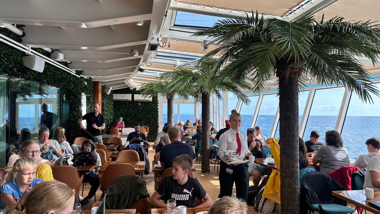
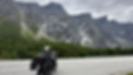
Eager to begin the next leg of our trip, we awoke early to catch the 8:30 am ferry to the southern tip of Norway! After strapping our bikes down for the journey, we made our way up to the breakfast buffet area. Brian had figured out that if we booked the buffet we would get a guaranteed seat and unlimited food for the entire journey, which was a much better deal than a regular ticket. However, if you have read any of our previous posts, you will know I am not the biggest fan of sea travel as I am very prone to seasickness. Thankfully, the combination of calm seas and Dramamine allowed me to fully enjoy the breakfast spread during our three-hour crossing.


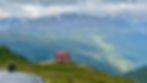
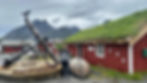
As we exited the ship, we were welcomed into Norway with a rain shower. Despite the gray skies and scattered rain, we couldn’t help but smile as we wound our way past countless lakes and through stunning green hillsides. The narrow two-way roads were made all the more exciting by the frequent sheep encounters we had around many of the corners. The sightings I got the most excited about, however, were all of the adorable houses and buildings with grass growing on the roofs (hairy houses as I liked to call them). We spotted many of these hairy houses throughout Norway and learned that sod roofs are an old Scandinavian tradition that dates back to the Viking and Middle Ages. They were (and still are) used for insulation, water management, and erosion prevention.


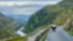
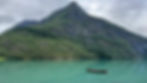
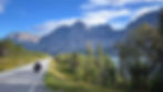
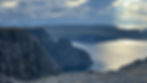
When we got to the famous Lysevegen Road, we flew the drone to admire the 27 hairpin turns over the Sirdal Valley and Lysefjord. The views were incredible and the road was empty making it all the more fun as we took turn after turn down into the valley. We would have ridden up and down the pass a second time if it weren’t for the waning daylight hours.


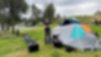
We found a campsite at the bottom of the road in the town of Lysebotn. It started to rain again so we quickly set up our tent and took shelter under the cover of the camp restaurant. We split a very expensive burger and fries as we watched the sunset over the fjord.


The next morning we awoke to hike a very popular trail in the region called Kjerag. Unfortunately, the weather had other plans for us. After enjoying the twisty turns of the Lysevegen Road again, we found ourselves surrounded by thick clouds and mist. We decided to try and wait for the fog to pass in the mountain overlook cafe, but after an hour of waiting the clouds only continued to roll in. We spoke with a person in the small tourist information kiosk who recommended we come back at 5:00 pm. Kjerag is a popular base jumping mountain and her base jumping friends were convinced there would be a weather window then. Thus, we rode back down the pass and got lunch in the cafe across the street from our campsite.


When we made our way back up the mountain just before 5:00 pm, there were still a lot of clouds but the heavy fog had lifted. Being from Colorado where afternoon thunderstorms and lightning can make a late mountain ascent dangerous, it felt odd to start a hike so late in the day, but we decided to give it a go. As we made our way up the steep and slippery mountainside with the help of the bolted chains, the clouds opened up and gave us a gorgeous view down into the fjord.


As we continued climbing we entered a new layer of clouds and mist but pressed on. After two hours of hiking, we reached our destination - the Kjerag Bolt. The Kjerag Bolt is a famous boulder wedged precariously in a mountain crevice 3,000 ft over the Lysefjord. Given the wet and slippery conditions, I decided to scoot cautiously and sit on the rock rather than stand like many people do, but it still provided an incredible vantage point down into the fjord below.


After taking some time to enjoy the view of the fjord through the clouds, we began our descent. With the slippery conditions, it took us two hours to cautiously make our way down the steep rock face. We were very thankful for the bolted chains in this direction and made it back to the bikes around 9:30 pm. We used the remaining bit of daylight to ride back down the pass to our campsite.


The next morning we packed up our tent and rode up the Lysevegen Road one last time before taking the southern route along the Lysefjord. There is a popular ferry that takes you through the fjord and is apparently very scenic, but it is one of the few ferries that you have to book in advance. The route we took was supposedly less scenic, but we found it to be beautiful and preferred riding to sitting on a boat for multiple hours anyway. We did eventually hop on a short ferry that took us across the fjord before we rode the rest of the way to the Preikestolen campsite.


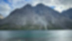
Preikestolen, also known as Pulpit Rock, is a famous cliff in Norway that sits about 2,000 ft above the Lysefjord. Its dramatic drop-off and flat top are an iconic hiking destination and were also used for filming a fight scene in the 2018 Mission Impossible movie. Given its popularity with tourists, we decided to wake up at 3:45 am the following morning and ride the seven minutes down the road to the trailhead to begin hiking at dawn. We had the trail almost completely to ourselves as we made our way up the route which included three sections of steep stone steps.


After about an hour and a half of climbing, we reached the top. The views were absolutely breathtaking! We were two of only six people on the summit and we all alternated taking photos with the mesmerizing view. We had hoped to fly the drone to really get an appreciation for the scenery, but the incredibly strong wind convinced us otherwise. In fact, we spent a bit of time on our stomachs with our head and arms hanging off and looking down the cliffside because the wind made it feel like we were skydiving.


Gradually, more and more people began joining us on the summit. What had been a quiet and serene spot quickly became crowded and noisy with other tourists. Feeling validated about our early start, we began the descent down through the throngs of people. We quickly rode back to our campsite, showered, and packed up our tent before 11:00 am to avoid paying for another night.
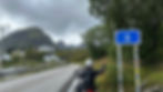
We rode through constantly alternating pockets of rain and no rain and actually managed to see some sunshine! While waiting for a ferry, we met two Polish riders Peter and Dominik. We had passed them on the hike earlier that morning and were impressed they had done the hike in their riding gear, carrying their helmets all the way to the top. They told us about a nearby must-do scenic road over a tunnel called Røldalsfjellet Turistveg. We had quickly learned that every day of travel through Norway involves at least one ferry and multiple absurdly long tunnels. We would happily take a scenic road instead of a 10+ kilometer tunnel. We thanked our friends for the intel and headed down the road. The scenic route was absolutely stunning and took us on a narrow twisty road past waterfalls and snow-capped peaks.


After checking the weather forecast and seeing heavy rain predicted for that evening and the following day, we decided to splurge on a room in a hostel in the town of Odda. The owner was kind enough to let us do some much-needed laundry.

Odda is located on the southern end of the Sørfjorden. It is the jumping-off point for one of the most popular hikes in Norway, the Trolltunga. When we awoke to pouring rain the next morning and saw that the forecast showed heavy rain for the next few days, we decided the Trolltunga would be a hike to save for another trip. Instead, we spent the morning trying to devise a new plan. Although Norway is known for having a lot of rain and often having multiple seasons in one day, the 10-day forecast for all of Central and Southern Norway was looking particularly terrible, especially since our plan was to camp as many nights as possible. We vacillated over the best route until we finally decided to just press on and enjoy the roads - rain or shine!
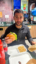
On our way out of town we stopped for our most frequent cheap(er) meal of the trip - a gas station hamburger. I will admit that we didn’t explore much of the culinary scene during our time in Norway as restaurant prices were steep, but the gas station hamburgers were actually quite good!
We made our way along Route 13 for most of the day, taking a detour to Ulvick on the 572. Unsurprisingly, there were many long tunnels through the mountains on the route, but what we were surprised to find was that one of the tunnels was so expansive it had two roundabouts in the middle!


We continued along Route 7 and around the Hardangerfjord before stopping for the night in the city of Bergen. We had hoped to find a covered spot to set up our tent as Norway has a “right to roam” law that allows you to camp anywhere as long as you follow a few rules including staying 150 meters away from any inhabited homes, but we had no luck. Instead, with more rain in the forecast, we found a hotel on the outskirts of the city and settled in for the night.
The following morning, we waited for a break in the rain and then rode the bikes into downtown Bergen.


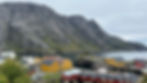
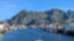
Home to Norway’s busiest port and surrounded by seven mountains, Bergen is the second largest city in Norway. The colorful waterfront area is a historic wharf and UNESCO World Heritage Site. After taking shelter from a sudden downpour, we were lucky to reach the waterfront just as the sun popped out from behind the clouds.


The sun was well-timed but short-lived. After taking in the view, walking through the fish market, and riding along the water, we found ourselves in another downpour. It was a cold and wet day, and we got rained on for the majority of the ride, but the views of the towering mountains lining the valleys were spectacular.


At one point during the ride, we passed through the longest road tunnel in the world: the Laerdal Tunnel. A whopping 25 kilometers and 20 minutes later, we were on the other side!

We stopped for dinner and to warm ourselves up at a marina restaurant in the village of Flåm. The village is nestled in a beautiful valley with a stunning view of the Aurlandsfjord.

We were tempted to camp here for the night, but opted to press on an hour and a half farther to a campsite in the town of Bøflaten. With more rain in the forecast, we decided to book an adorable tiny cabin.


Given the high levels of rain throughout Norway, most campsites have some sort of basic tiny cabin. When we awoke to pouring rain the following morning, we chose to spend another night in the cabin and wait out the weather. We spent the day doing some trip planning, chatting with a nice Dutch family, and watching some downloaded shows. It rained almost constantly the entire day and we were thankful for our shelter.


Another thing we were thankful for was the YX gas station across the street. We had heard from another traveler that YX gas stations have reusable mugs that, once purchased, can be used for unlimited coffee and hot chocolate refills at any YX station! This tiny mug would bring us much joy on the cold and rainy days ahead!

The following morning, the sun was actually shining as we packed up the bikes! We stopped for some photos along the campsite’s waterfront.


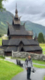
Within five minutes of leaving, however, it began to rain. We pressed on to one of Norway’s most well-preserved stave churches, the Borgund Stave Church. During the Middle Ages, the Vikings built over 1,000 of these ornate wooden churches to celebrate the birth of Christianity in Norway. Today, just 28 remain and most have undergone extensive restoration. Still, these churches are an iconic sight in Norway and no trip is complete without a visit to one of them.

After admiring the church, we opted to take a route recommended by the Bøflaten campsite owner despite the not-so-great weather forecast in the region. The route took us up to 8,000 ft on some passes near Jotunheimen National Park. It was 40 degrees Fahrenheit with heavy rain most of the time, so we didn’t make it all the way into the park, but the vistas were still gorgeous.


While coming down the pass, we saw a rider in the road but off his bike with evidence of a recent crash, so we stopped to see if he was okay. It turned out that Daniel had in fact fallen off of his bike and he was concerned he had fractured his clavicle. It was pouring rain and we were all stopped in the middle of the road. Daniel was unable to ride his bike so Brian hopped on his comically tall and overloaded GS with a raised seat cushion and limped the bike down the hill to a pull-off. Brian says getting the kickstand down while on the bike was the most challenging thing he had done on the trip so far (I wish I had gotten a video). Once we were all safely in the pull-off, we took cover under a little rock overhang. We flagged a car down to ask what the emergency line is in Norway and then gave it a call. We were impressed with the emergency response services as they initially offered to send a helicopter, but Daniel declined, opting not to risk a helicopter ride in the bad weather. Shortly after, an off-duty nurse and her husband who is an SOS International driver pulled over and approached us. They had somehow gotten word of the 311 call and were nearby on holiday and decided to stop and help while we waited for the ambulance. Once the ambulance and police arrived and we knew Daniel was in good hands, we rode a little farther down the mountain to a hotel to dry off and warm up with some coffee as it was still pouring rain.


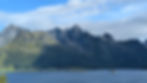
We waited out the heavy rain and then rode a little farther up the Sognefjellet Scenic Road with great views of the Jotunheimen Mountains including Norway’s tallest mountain, the Galdhøpiggen.

It was still raining, but we managed to find a few breaks in the clouds and even an occasional sliver of sun. The air began to warm and the rain subsided as we descended past gushing waterfalls and eventually found ourselves at a picturesque turquoise lake.


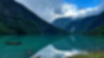
We took in the view for 10 minutes before the rain caught up with us turning the placid looking glass water into a kaleidoscope of movement. We continued riding toward the village of Sogndal where we had booked a cheap room for the night. We got one final short break in the rain as we rode along the pristine Sognefjord on our way into town.

The following morning, we packed up the bikes and rode to the Bøyabreen Glacier. Surrounded by waterfalls, the glacier sits above a beautiful glacial lake. We admired the view until a rainstorm rolled in.


Next, we rode to the village of Loen for lunch before taking a detour to the Lovatnet Lake. We rode along the edge of the bright blue glacial water for a bit before turning back to continue on to Stryn.


From Stryn we rode up 3,700 ft on the Gamle Strynefjellsvegen Scenic Road. For about 30 kilometers near the top we navigated through silty dirt that felt more like mud and it took a bit of concentration to keep the bikes upright, but the views of the surrounding mountains and lakes were stunning.


We welcomed the warmth of lower elevation as we made our way down and continued on to our destination for the day, Geiranger. The road into Geiranger was fun and twisty, however, we often found ourselves stuck behind large buses. Geiranger is a popular cruise ship docking point and when a ship is in the port the buses seem to take over the roads.


We arrived in the small village on the edge of the Geirangerfjord and set up our tent at the only campsite in town. We managed to assemble our tent and walk into town for dinner before 8:00 pm - a new record for us this trip.


After a very restful night of sleep thanks to the calming sounds of a nearby stream, we awoke to sunshine! The forecast was looking great and we were eager to take advantage of the good weather window. We left our luggage at camp and road north toward the Trollstigen pass, aka Troll Road. Trolls are prevalent in Nordic Folklore and Norse Mythology, and troll-themed names and items can be found all over Norway. This particular pass is considered one of the most scenic roads in all of Norway. Its steep hairpin turns surrounded by mountains and waterfalls lead down into the Romsdalen Valley. Unfortunately, the hairpin section of the pass was closed due to recent heavy rockfall. We knew this prior to going, but had heard the ride up the other side of the pass was still worth doing. We arrived at the ferry to cross the Geirangerfjord just as the stream of cars began to trickle on and we didn’t even have to put a foot down - we just rode right onto the ship.


Once on the other side, we took the twisty road through the valley toward the Trollstigen, flying the drone a few times along the way. The road and vistas were incredible, and we were euphoric from the continual sunshine.


We cruised down the road as far as we were allowed to go and then parked at the pass cafe. We had lunch and then walked the short trail to the pass overlook that teased us with epic views of the sweeping hairpin turns down into the valley below.


After flying the drone and enjoying the view for a while, we took the same road back toward Geiranger, reveling in the persisting sunshine. One benefit of the pass being closed was that there weren’t too many other vehicles to contend with and we could enjoy the flowy road without much interruption. Our ferry luck continued and we managed to time our arrival perfectly to cross the fjord back to Geiranger. Once on the other side, we passed our campsite and continued south along the road we had taken into Geiranger the previous evening, but this time in the warmth of sunshine!


We then decided to ride up the Dalsnibba toll road to see Europe’s highest fjord view by road. It was money well spent as the views were incredible and the road was twisty and fun!


It was a little past 7:00 pm by the time we began making our way back down to our campsite. It was the witching hour (as we like to call it), and the road was completely empty of buses and cars. We smiled through the turns as we sped down the road back to camp. We enjoyed a freeze-dried meal and some nice conversation with our Swedish camping neighbors before collapsing in our tent. This was our first day with zero rain and we could not have been happier as we drifted off to sleep.


The following morning we packed up our campsite and left Geiranger. We considered taking the scenic ferry along the length of the Geirangerfjord as it is apparently very beautiful, but it was expensive and we were anxious to keep riding. When it started raining 10 minutes after leaving, we felt validated in our decision. Luckily, however, this small section of light rain was our only rain of the day! We took the short ferry across to the other side of the fjord and made our way along multiple stunning fjord roads to the town of Åndalsnes.

We found a Thai food truck and ate some delicious curry for lunch - a welcome change to our usual gas station hamburger.


Next, we took a detour to see the tallest vertical rock face in Europe - the Trollveggen, or Troll Wall. Standing below this imposing rock face that towers over 3,500 ft into the sky felt like something out of a fantasy novel. The surrounding landscape reminded us of the Dolomites and Patagonia combined. We felt the scenery demanded that we fly the drone to take it in from above, but we realized we probably should have listened to our low battery warning when 30 seconds into flying Brian was forced to do an abrupt hard landing just barely missing the busy road.


As we were leaving, the sun came out and illuminated the landscape making the scenery feel even more magical. At this point, however, we were a little photo-ed out, so we mostly just enjoyed the ride and committed the views to memory.


We had one final ferry to get to our destination for the evening - a town called Molde. Our luck from the previous day had run out and we just missed the ferry leaving. After waiting for the next one and making it to the other side, we rode the winding road another 30 minutes to a cabin we had booked earlier in the day. We arrived around 8:00 pm and initially thought the owner was joking when he said Booking.com had made an error and he had no available space for us. As we sat outside waiting for Booking to call us back, Brian and I decided to start eating some of the food we had picked up at the grocery store on the way in. Tired and delirious from the long day, I laughed so hard I cried when Brian had me try his yogurt that tasted like unsweetened tapioca pudding and cardboard with a label that translated to “Dried B Blaber & Crisis.”


Booking eventually called us back and offered to put us up in a shwanky hotel down the road at no additional cost! It felt like pure luxury after so many nights of camping and very basic accommodations. We walked along the dock and enjoyed our waterfront view before retiring to our gloriously comfortable bed.


After enjoying the hotel’s delicious complimentary breakfast, we embarked on a route that would take us on what some people consider the world’s most beautiful drive. Spanning 8.3 kilometers and comprised of eight arching bridges, the Atlantic Ocean Road road meanders over the sea with expansive views of the ocean on both sides. Although we would not call it the most beautiful drive in the world, we did enjoy the views on this short stretch of road, even with the gloomy weather.


Despite the gloomy skies, we managed to avoid the rain all day. After another well-timed ferry crossing and a bit more riding, we arrived in the city of Trondheim.

Our visit to Trondheim was not only because Trondheim is a popular tourist destination, but also because one of Brian’s friends from his D.C. days lives there. Brian’s friend Kam was gracious enough to offer to host us. We spent the evening chatting with Kam, her husband Felix, and Kam’s mom Theresa. We also got to meet Kam and Felix’s adorable daughter Philomena. Unfortunately, Kam started feeling sick that evening so Brian and I went out to explore the old town and have dinner just the two of us.


The next day, Kam was still feeling unwell so Brian and I decided to have a relaxing day off the bikes. After doing some laundry and getting a workout in at the local gym, we walked down the street to a traditional Norwegian restaurant called Baklandet Skydsstation and tried their famous reindeer stew. It was delicious! We spent the rest of the afternoon walking around town and relaxing.


After a night of intense wind and rain that made us grateful we weren’t camping, we awoke to sunshine. We said goodbye to Kam and Felix and made our way toward the Coastal Highway (County Road 17). This day’s route felt more remote as we saw far less camper vans and other vehicles. We enjoyed the nice winding roads along the water and through the mountains - so much that we didn’t take any photos or videos. We finished the day with the first of a series of ferries that would take us north. This particular ferry to Vennesund was incredibly rocky, but I was distracted from my discomfort and seasickness by two new friends we made on the boat: Ani and Deyan, a Bulgarian couple riding north on a Yamaha Tracer. Once on the other side, we found a container cabin at a campsite just down the road and settled in for the night.

The next day we had planned to take five ferries along the Coastal Highway, but our plans were quickly thwarted. So far, our experience with ferries in Norway had led us to believe that if you miss one ferry, the next one will arrive in 20-30 minutes. Thus, we hadn’t bothered checking the timetables up until this point. When we pulled up to our first ferry of the day and saw that the next ferry didn’t arrive for another two hours, we realized this was a mistake. It was raining, so we took shelter under the roof of a nearby building and contemplated our options. Rather than wait in the rain for two hours, we decided to make a two-hour detour back inland onto the E6 and reconnect with the ferry route farther north. This detour ended up being a fantastic twisty road with barely any cars! We enjoyed pockets of sunshine and gorgeous mountain views along the way.

We eventually reconnected with the Coastal Highway and caught the short ferry from Levang to Nesna.

After another 90 kilometers of riding along the beautiful coast, we took our final ferry of the day from Kilboghamn to Jektvik. During this 60-minute ride, we officially crossed the Arctic Circle! This was the farthest north either of us had ever been, and it felt surreal to see our little blue dot that high up on the map, knowing we still had more northward distance to go.


Once on the other side, we decided to stop and set up camp for the night. We found a campsite in a friendly 70-year-old man’s backyard. I think it is worth mentioning here that cash payments are not common in Norway. Per the advice of our Kiwi friends who had recently traveled through Norway, we had not even taken out cash from an ATM yet, as every place accepts and prefers card payments. When we told the 70-year-old man we didn’t have any cash, he promptly pulled out his credit card reader like it was nothing. Funny enough, we would go the entire three weeks without ever handling any Norwegian Krone.


We had a nice weather window the next morning and our tent was actually dry when we packed it up. We rode 28 kilometers along stunning mountains to our first and shortest ferry of the day.


We got our first views of the Svartisen glacier on the ferry and stopped at one of the glacier viewpoints on the other side.


The remaining stretch of the Coastal Highway took us 177 kilometers along the water up to the town of Bodø. Per the recommendation of other riders, we decided to take a ferry from Bodø to the westernmost point of the Lofoten Islands to maximize our time in the archipelago and avoid having to backtrack. The only catch - the Lofoten Islands are draped across the turbulent waters of the Norwegian Sea. I think our long ferry crossing from Denmark to Norway had given me a false sense of confidence, but the open ocean on this crossing quickly changed that. I spent the next four hours seriously questioning my life choices as the boat pitched and rolled over the 10-12 ft waves. The crew passed out barf bags and many people on the boat utilized them. I managed to sit out in the rain for the entire journey and willed myself to not get sick as the horizon came in and out of view with each crash of the boat over the waves.


The one positive from this crossing was that we ran into our Bulgarian friends, Ani and Deyan, again. When the boat docked just before sunset in Moskenes, we exited the ship in a massive downpour and dashed over to the only campsite nearby. There weren’t many spaces left, but we managed to squeeze our tent into a small soggy opening and retreated to a sheltered table to make dinner. We spent the rest of the evening chatting and laughing with Ani, Deyan, and some of the other campers.

The next morning began with alternating sun and downpours every 10 minutes. We waited for a pocket of sunshine and then left camp to hike the most popular trail on the Lofoten Islands - the Reinebringen. The trail is a short but steep hike up stone steps that lead to an epic view overlooking the Reinefjord and Kjerkfjord and the villages of Reine, Sakrisøy, and Hamnøy. When we reached the summit, the view was absolutely breathtaking! We spent about an hour watching the scenery change as the sunshine was punctuated by rainshowers and rainbows.


I could have happily stared at this view all day, but hunger eventually led us back down the steps and into a cafe in town. We enjoyed some fish and chips and then rode to the uniquely named nearby village of Å. Once just a small fishing village specializing in stockfish, this town is now a popular tourist destination, however, it manages to maintain its charm. We walked along the quaint streets and enjoyed the beautiful views before riding back to camp and relaxing for the rest of the evening.


There was crazy rain and wind overnight. After getting woken up by the tent tapping us on the head, we waited for the worst of the rain to pass before hitting the road. Despite the clouds, the views along the fjords were gorgeous. I don’t think the combination of towering mountains on one side and tranquil seaside views on the other could ever get old. We rode through the villages of Sund and Fredvang and then stopped for lunch in Ramberg.


Next, we visited Nusfjord, one of the oldest and best-preserved fishing villages.
After stopping for dinner in Leknes, we rode to Haukland Beach to find a wild camping spot that one of our friends from Motocamp Bulgaria had recommended. We found a grassy spot near the beach and set up camp for the night.
We spent the following morning hiding in our tent from the rain until the sun finally came out around 10:30 am. We made our way to a nearby beach and then rode to Unstad, a popular arctic surfing spot. We marveled at the brave surfers submerged in the icy-cold water, before escaping inside from the wind to a cafe with a sign claiming to have “the best cinnamon buns in the world.”


Rejuvenated from our sugar high, we rode through a few more seaside villages, including Eggum (my personal favorite village name).


As the temperature dropped and a heavy rainstorm rolled in, we decided to visit the nearby Lofotr Viking Museum. The museum is inside a reconstructed version of the largest Viking longhouse ever excavated. It gave us a small glimpse into what life in one of these longhouses might have been like in the Viking Age.


It was still raining when we left the museum and more heavy rain was in the forecast, so we decided to book a basic hotel near the village of Henningsvær. We warmed ourselves up with a hot shower before walking 10 minutes across a bridge and into town in the rain. We enjoyed a nice dinner with a view as well as a beautiful sunset as the rain subsided on our walk back to the hotel.


The following morning, the sun was shining and spirits were high. We coudn’t help but smile as we made our way to the iconic Henningsvær football pitch. The football pitch is in a spectacular setting surrounded by water on the tip of Henningsvær. The excellent weather provided perfect conditions for flying the drone to really appreciate its unique location.


Next, we took the E10 east along the remainder of the Lofoten archipelago, the good weather following us the whole way. At this point, we had a decision to make. Prior to embarking on this trip, we had tossed around the idea of riding all the way to the top of Norway to a bucketlist destination called Nordkapp. Not ones to just check boxes, we had decided early on that we would make the push north from the Lofoten Islands only if it felt right and the weather looked good. With the forecast in our favor, it felt wrong to turn back now. Thus, from Lofoten we veered north to the village of Andenes.


While waiting for a ferry from Andenes to Senja Island we met Tina and Christian, two friendly riders from Austria. We chatted with them for the entire hour and forty minute ride, sharing stories and route plans.


We took the scenic route on Senja Island, riding up a few of the island’s northern peninsulas. It was golden hour and the mountains and water were beautifully illuminated.


We had planned to catch the 9:30 pm ferry to continue northeast and set ourselves up well for the following day, but when we arrived at the dock we saw the ferry had been cancelled. Instead, we found a quiet campsite, set up our tent, and watched the last rays of light dip below the horizon.


We caught the 9:45 am ferry the following morning and rode an hour to the city of Tromsø. Tromsø is the largest urban area in Northern Norway. It felt odd to be in the hustle and bustle of a city again. After getting lunch downtown, Brian opted to go visit the Polar Museum, a museum about the history of trappers and explorers in the region, while I took some time to explore the downtown area (including grabbing a coffee from the northernmost McDonald’s in the world).


We rejoined later in the afternoon and rushed through the city traffic to catch our second of three ferries for the day. We made it just in time and enjoyed some of the best ferry views thus far. Brian also favored this ferry ride because two German Air Force Tornadoes flew close overhead during the crossing. We still have no idea what they were doing there.


We had read that our last ferry of the day was scheduled so that drivers would have just enough time to make it from one ferry to the other. Thus, we rushed down the road and marveled at the striking Lyngen Alps, but didn’t stop to take any pictures. When we arrived at the dock for the other ferry, we saw the next one didn’t come for another hour and a half. We weren’t too sad, however, because this meant we had time to go back and ride the road again!
We caught the last ferry of the day and enjoyed beautiful views of the sunset over the glaciated mountains on the water.

On the other side, we took a fun, twisty, and car-free road over the mountains to our homestay for the night. Zigy, the guy I mentioned in the last post whom Brian met up with in Boulder prior to our trip, had also connected us with Louise, a Danish woman living on a gorgeous remote property just south of Alta. She graciously offered to host us in her guest cabin, free of charge. She was an incredible host and we enjoyed some wonderful conversation, talking about her time as an Occupational Therapist in remote Greenland, what its like to live in such a remote area above the Arctic Circle, and the history of the region and the native semi-nomadic Sami people. We also fell in love with her adorable husky/malamut dog Rasmus and her cat Suki. We only spent one evening there, but Louise is one of those people that we will remember forever and we are grateful for her hospitality.

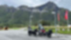
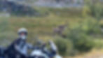
After a relaxing morning chatting over coffee and a group photo shoot, we said goodbye to Louise, Rasmus, and Suki and began the final stretch of road to the northernmost driveable point of Norway - Nordkapp. We saw the first (of MANY) reindeer as we popped in and out of sunshine on the twisty road. The scenery transitioned from coastal ocean views to barren otherworldly terrain as we continued north. Other riders had told us that this final stretch of road was boring, but we could not disagree more.


Five hours later, we finally arrived at Nordkapp! The ride up to Nordkapp, or North Cape, is a right of passage for many motorcyclists. Standing at a latitude of 71° North, it felt surreal as we gazed out into the vastness of the Arctic Ocean. We had made it to the “top of Europe” as many people call it, and we paused a moment to process and take it all in. We spent a few hours exploring the visitor center exhibits and taking photos on the North Cape Plateau with the iconic globe sculpture.


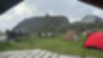
Given the number of other tourists that visit this landmark every day and the inability to take vehicles out onto the cape during visitor center hours, many motorcyclists will go very early in the morning before anyone else arrives to get the classic motorcycle photo with the globe. Since the nearest campsite is over 20 minutes away, we decided to stake out a wild camping spot just off the road a couple kilometers away from the visitor center. We had checked the weather forecast and all was looking good. We found a nice flat spot and began setting up our tent. A few minutes later, the sky turned dark and the wind began to strengthen. We had just started to put our tent poles together when a wall of rain and gale force winds hit us. We quickly scrambled to get the tent assembled and the rainfly on so we could get ourselves and our gear under shelter. The winds, however, made this very difficult and we found ourselves struggling to keep the tent from collapsing on itself. We ended up securing the tent as best we could and then retreating inside our half-built shelter. Since the storm hadn’t been in the forecast, we assumed it would pass quickly and we could assemble the tent properly once it did. About an hour later, the wind and rain still hadn’t let up. Oddly enough, our weather apps were still telling us 0% chance of rain. We went outside multiple times to try and fix the tent, but we could not figure out why it kept collapsing. We decided a collapsed tent was better than no tent and opted not to risk undoing our stakes and having the tent fly away.

Still wearing our motorcycle gear and with no space to blow up our air mattresses, we did our best to just close our eyes and let the beating of the tent lull us to sleep. We managed to get a fitful two hours of sleep before Brian awoke and nudged me. It was 6:00 am and if we wanted to salvage our day and get the photos we would need to leave. Luckily, the rain had passed but the winds were still raging. We mounted our bikes and cautiously rode the 2 kilometers back to the visitor center. This was by far the craziest wind I had ever ridden in. We struggled to navigate over the rocky section leading up to the sculpture, fighting to keep our bikes upright against massive gusts of wind, but we eventually made it! We recruited a bikepacker to get some photos of us but didn’t dare to lift our kickstands as they were the only things keeping us upright in these photos.


In retrospect, the photos probably weren’t worth the drama, but we will forever remember our eventful night of wild camping at the top of Europe.
We rode back to our still-collapsed tent, packed up the bikes, and began our journey south toward Finland!